
December 5, 1996
by Sylvain Comeau
| |
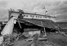
| Atmospheric and oceanic sciences professor Charles Lin | Massive flooding in the Saguenay region this summer resulted in over $450 million in damages |
Last summer's massive flooding in the Saguenay region was a brutal and devastating event which could not have been predicted. Or could it?
A group of Montreal university researchers are collaborating to develop a computer model which can predict severe precipitation--like the heavy rains which caused so much damage in Quebec.
Called the Mesoscale Compressible Community Model (MC2), this tool gives information at a much higher resolution and covering a much smaller geographic area than previous models were capable of. Environment Canada, which developed the program, is collaborating with McGill atmospheric and oceanic sciences professor Charles Lin, director of an environmental group at CERCA (Centre for Research on Computation and its Applications), a joint research centre run by Concordia, Université de Montréal, McGill and École Polytechnique. Although they're interested in forecasting future events, Lin and his group also want to know if MC2 can first demonstrate a gift for hindsight.
"We want to see if MC2 can perform what we call a 'hindcast' of the precipitation which led to the Saguenay flooding. If so, we would be able to have more confidence in the program's ability to accurately forecast events like that," says Lin. "Past performance helps a lot in risk management decisions."
Lin explains that a hindcast is the computer simulation of an event which has already occurred. MC2 works by starting with routinely available observations of the atmosphere at a specific time. "If we want to know what happened at a particular place and time, we set up the model grid over a region which is much larger than the area we're actually interested in. That area could be most of the country. We furnish information on the atmospheric conditions such as temperature and wind velocity at the boundaries of the model, to get the model started."
The next step will be to narrow the focus onto the Saguenay area.
"We start with a spatial resolution of the model data of 35 km, then zoom in to one of 10 km, or 5 km, or even less. At these higher and higher levels of resolution, the model generates its own data, based on the observed conditions which we fed into it at the model's boundaries. There is little observed data within 10 or 5 km; that's why we have to do it this way."
Lin says his team is working on expanding MC2's applications by combining it with other existing models.
"Meteorological models are concerned with amounts of precipitation, but they don't say what happens to all that water. That's where hydrological models come in. These models predict the flow of water over different land forms. Our job is to couple MC2 to a hydrological model."
Lin and his CERCA collaborators--including post-doctoral fellow Wei Yu and computer programmer Michel Béland--are seeking sponsorship for that project. Currently, as a CERCA industrial partner, Environment Canada is providing computer support, but progress will be slow until other government or industrial partners come on board. They have, however, already completed the first step.
"What we have shown is that MC2 is capable of giving precipitation amounts which are reasonably close to what is observed by the meteorological stations in the Saguenay region. That means that if we drive the hydrological model with this information, we should get encouraging results--in other words, we should be able to explain how that precipitation caused the flooding."
Meanwhile, says Lin, the Department of Fisheries and Oceans is sponsoring another project using MC2. "To safeguard shipping routes, they're interested in forecasting the motion of ice in the Gulf of St. Lawrence, so that they can issue warnings in case of ice jams.
"As with the flooding, to help give confidence in MC2's forecasting ability we are going to do a hindcast, probably of an unusually cold period of time in the Gulf, say in the middle of February. We will compare the simulated winds and temperatures with observed winds and temperatures over a one-week period."
That particular project will demonstrate not only the model's forecasting ability, but its versatility as well.
"Instead of using a hydrological model to answer the question 'Where is the water going?' we're using an ice-ocean model to answer the question 'Where is the ice going?' The MC2 thus helps provide answers to a number of different environmental questions."
CERCA is holding a two-day workshop on Environmental System Modeling of Severe Precipitation Events today and Friday. The event is sponsored by McGill, Environment Canada, and the Cooperative Centre for Research in Mesometeorology.